Beiträge mit #PythonGIS

#PythonGIS

Öffentliche Beiträge auf X, die #PythonGIS verwenden.

Verwandte Hashtags

  1. Milos✓@milos_gis
    Top 5 Most Used Python Packages for GIS in 2024! If you're diving into geospatial analysis, mapping, or data viz, these libraries are game-changers. Based on community usage and mentions across sources, here's my rundown. Let's boost your skills! 🧵
    Herunterladen
    217968.1K
  2. Milos✓@milos_gis
    @milos_gis
    5/6 Rasterio: What it does - Reads/writes geospatial raster data (e.g., GeoTIFF); supports masking, reprojection & stats. How to use: pip install rasterio import rasterio with as src: print(src.profile) Processed satellite data with it? Spill the beans! 🛰️ #EarthObservation
    Herunterladen
    1121.4K
  3. Milos✓@milos_gis
    @milos_gis
    6/6 There you have it—the top 5 Python GIS powerhouses of 2024! These tools democratize spatial data work. Which one's your fave, or did I miss one? Drop comments, RT for fellow coders, and follow for more threads! Let's discuss projects. 👇 #TechTips #PythonGIS
    Milos @milos_gis
    Top 5 Most Used Python Packages for GIS in 2024! If you're diving into geospatial analysis, mapping, or data viz, these libraries are game-changers. Based on community usage and mentions across sources, here's my rundown. Let's boost your skills! 🧵
    0041.5K
  4. Henrikki Tenkanen 🌐 htenkanen.bsky.social@tenkahen
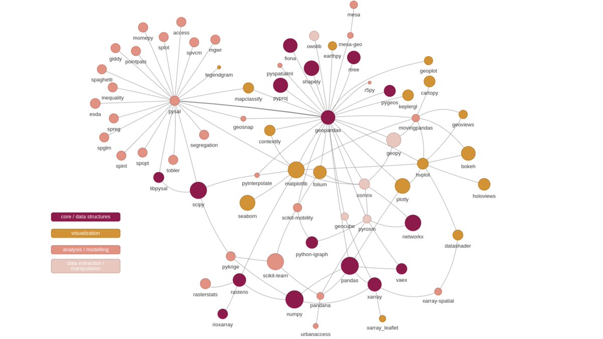
    #2 attempt to map the #GeoPython #PythonGIS ecosystem for our @pythongis project. Currently 123 libraries covering a broader spectrum of pkgs. Thanks a lot for everyone who answered the call and helped! 🙏😎 Will produce separate for vector+raster & interactive ones to play with.
    Herunterladen
    Henrikki Tenkanen 🌐 htenkanen.bsky.social @tenkahen
    My first attempt to map the #GeoPython #PythonGIS ecosystem (currently n=69) for our @pythongis project (vector+raster) 🤓 𝐇𝐞𝐥𝐩 𝐧𝐞𝐞𝐝𝐞𝐝: What packages do I miss? I'm sure there are plenty of interesting libraries escaping my radar 🧐 @geopandas @pysal_devs @xarray_dev
    1521
  5. Henrikki Tenkanen 🌐 htenkanen.bsky.social@tenkahen
    @tenkahen
    @pythongis @geopandas @pysal_devs @xarray_dev #2 version of the #PythonGIS universe is available here:
    Henrikki Tenkanen 🌐 htenkanen.bsky.social @tenkahen
    #2 attempt to map the #GeoPython #PythonGIS ecosystem for our @pythongis project. Currently 123 libraries covering a broader spectrum of pkgs. Thanks a lot for everyone who answered the call and helped! 🙏😎 Will produce separate for vector+raster & interactive ones to play with.
    104
  6. Simon✓@OmbuiSimio27785
    Day 25: 🛰️ Space and Ground Unite! Dive into the fusion of satellite and ground-based data in Python. Leverage libraries like Skyfield to bridge the gap between celestial observations and geospatial analyses. 🌌🌍 Github Link: #SpaceData #PythonGIS
    Herunterladen
    00161
  7. Mehr Beiträge anzeigen