NWS Tulsa

@NWStulsa

Official Twitter account for the National Weather Service Tulsa, Oklahoma. Details: https://t.co/Afr013XkGT

252 Following53.6K Followers46.2K Posts
  1. NWS Tulsa@NWStulsa
    [3:24 AM - 10/28/26] Breezy afternoon winds, warm temperatures, & low RH values will create enhanced fire spread rates across parts of E OK & NW AR this afternoon. The highest fire spread rates are forecast along & N of I-44 where winds will be the strongest. #okwx #arwx
    Download
    006860
  2. NWS Tulsa@NWStulsa
    The warm weather will continue for a while longer, but we are seeing some changes by late this week as the pattern becomes more unsettled. Details here: #okwx #arwx
    1052.5K
  3. NWS Tulsa@NWStulsa
    [1:25P - 10/26/26] The next chances for rain arrive Tuesday mainly across portions of E OK as an upper wave lifts northeast from west TX. Rainfall amounts should remain light and thunderstorms are not expected. #okwx
    Download
    00112.4K
  4. NWS Tulsa@NWStulsa
    [1:25A - 10/26/26] The weekend wx pattern favors higher rain chances. Looking specifically at Halloween, odds are about 50-50 for wet wx during the evening festivities. Isolated storms would also be possible during this time, and could impact outdoor activities. #okwx #arwx
    Download
    02112.1K
  5. NWS Tulsa@NWStulsa
    [11:50P - 10/25/26] The next chances for rain arrive Tuesday mainly across portions of E OK as an upper wave lifts northeast from west TX. Rainfall amounts should remain light and thunderstorms are not expected. #okwx
    Download
    02132.2K
  6. NWS Tulsa@NWStulsa
    [2:28A - 10/25/26] The weather pattern by next weekend favors higher precipitation chances. Looking specifically at Halloween, odds are about 50-50 for wet weather during the evening festivities. Isolated thunderstorms would also be possible during this time. #okwx #arwx
    Download
    01142.9K
  7. NWS Tulsa@NWStulsa
    [2:30 PM 10/24/26] - Mostly quiet weather this week as well above normal temperatures continue. A few showers may occur Tuesday with a better chance of rain next weekend. #okwx #arwx
    Download
    0151.8K
  8. NWS Tulsa@NWStulsa
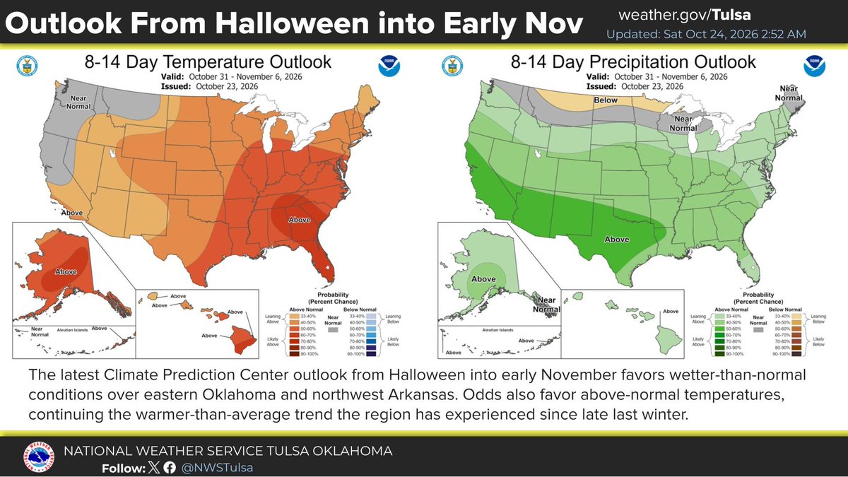
    [3:00A - 10/24/26] The outlook for week 2, covering Halloween into early Nov, continues to favor warmer and wetter than normal conditions across E OK and NW AR. #okwx #arwx
    Download
    21122.3K
  9. NWS Tulsa@NWStulsa
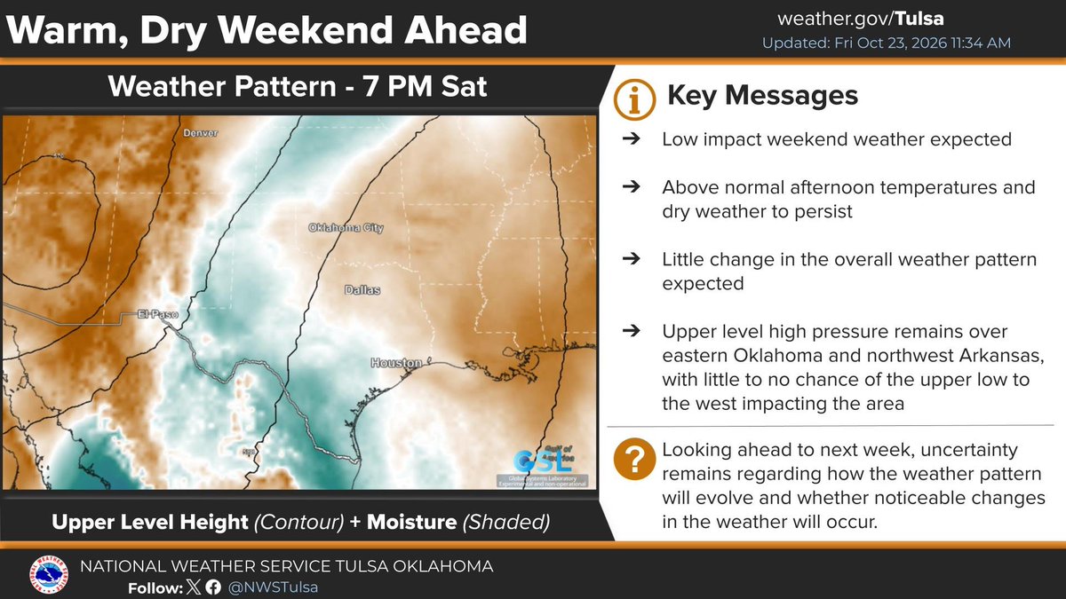
    [11:42 am - 10/23/26] Low impact weather, with warm and dry conditions, is expected to prevail across eastern Oklahoma and northwest Arkansas through the weekend. Enjoy the weather! #okwx #arwx
    Download
    0072K
  10. NWS Tulsa@NWStulsa
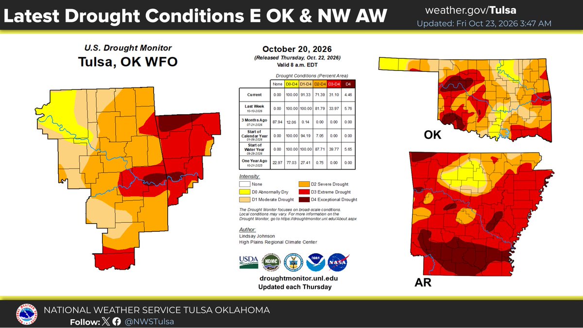
    [4:28 AM 10/23/26] Drought conditions from abnormally dry (yellow area) to exceptional drought (dark red area) exists over E OK and W AR. Latest forecast continues a chance of above normal temps with a lean toward higher precipitation potential late Oct - early Nov. #okwx #arwx
    Download
    0092.2K
  11. NWS Tulsa@NWStulsa
    [12:44 PM - 10/22/26] Here is a quick video going over the forecast for this weekend and into next week:
    0152.7K
  12. NWS Tulsa@NWStulsa
    [4:20AM 10/22/26] High pressure/dry conditions are forecast thru the weekend for E OK & NW AR. Low pressure system could move into the region w/the return of rain chances next week. Latest outlook for late Oct/early Nov is for above normal temps & above normal precip. #okwx #arwx
    Download
    0172.1K
  13. NWS Tulsa@NWStulsa
    [1 PM 10/21/26] A few brief light showers or sprinkles will continue through mid afternoon from NE OK into far NW AR. Measurable rainfall amounts are not likely and the trend will continue for decreasing rain chances through the afternoon.
    Download
    0142.1K
  14. NWS Tulsa@NWStulsa
    [10:25 AM 10/21/26] Isolated light rain showers will continue across NE OK into far NW AR through early afternoon. Any measurable rainfall amounts will remain less than one tenth of an inch. Rainfall chances continue to decrease through afternoon.
    Download
    0261.8K
  15. NWS Tulsa@NWStulsa
    [7:20 AM 10/21/26] Areas of light rain or sprinkles will spread east across NE OK into far NW AR through the morning. Any rainfall amounts remain light and less than one tenth of an inch.
    Download
    1091.8K
  16. NWS Tulsa@NWStulsa
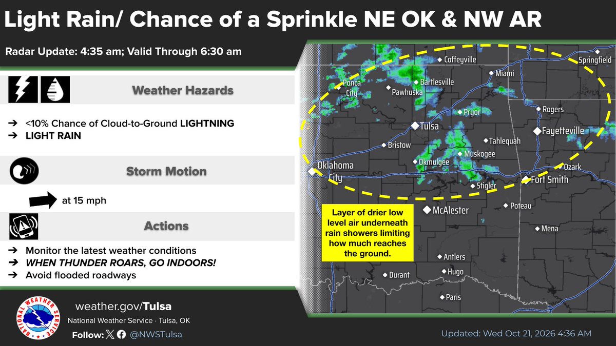
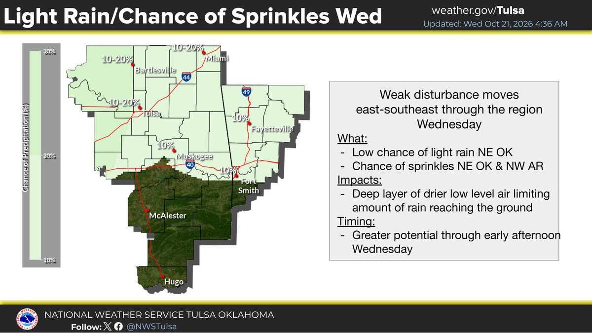
    [4:45 AM 10/21/26] Scattered light rain & the chance of a sprinkle moving over NE OK into NW AR early Wed AM will remain possible during the day as a disturbance moves thru the region. A layer of drier low level air will limit the amount of rain reaching the ground. #okwx #arwx
    Download
    0161.9K
  17. NWS Tulsa@NWStulsa
    [1:16 AM 10/21/26] Scattered light rain with a few embedded lightning strikes were moving into NE OK as a disturbance moves into the region. Drier air underneath the rain was limiting the amount reaching the ground. Movement was eastward around 15 mph. #okwx
    Download
    02121.8K
  18. NWS Tulsa@NWStulsa
    [4:44 AM 10/20/26] A weak disturbance moving into the Plains over the top of a deep layer of drier low level air over E OK & NW AR will continue to hinder most of any rain development from reaching the ground other than a chance of a sprinkle Tuesday and Wednesday. #okwx #arwx
    Download
    11152.4K
  19. NWS Tulsa@NWStulsa
    [2:30 pm - 10/19/26] Area radars are showing some scattered light rain in the region, but why is most of it not reaching the ground? The 7 am weather balloon data from Norman and Springfield tell the story. SCIENCE! #okwx #arwx
    Download
    13153.2K
  20. NWS Tulsa@NWStulsa
    [8:17 am - 10/19/26] The Day 8-14 outlook from the Climate Prediction Center continues to show potential for warmer and wetter than normal conditions in eastern Oklahoma and western Arkansas. What that means for Halloween specifically is still TBD. Stay tuned. #okwx #arwx
    Download
    00102.7K
  21. Show more posts