Posts with #WeatherExplained

#WeatherExplained

Public posts on X that use #WeatherExplained.

Related hashtags

  1. Sammy Hadi@SammyHadiWx
    #WeatherExplained: A simple cross-section and explanation of the structure of a Tropical Cyclone. #DYK: The reason why the "eye" of an intense tropical cyclone is clear is due to subsidence! As air sinks and warms in the eye, it acts to prevent cloud formation!
    Download
    0832
  2. Sammy Hadi@SammyHadiWx
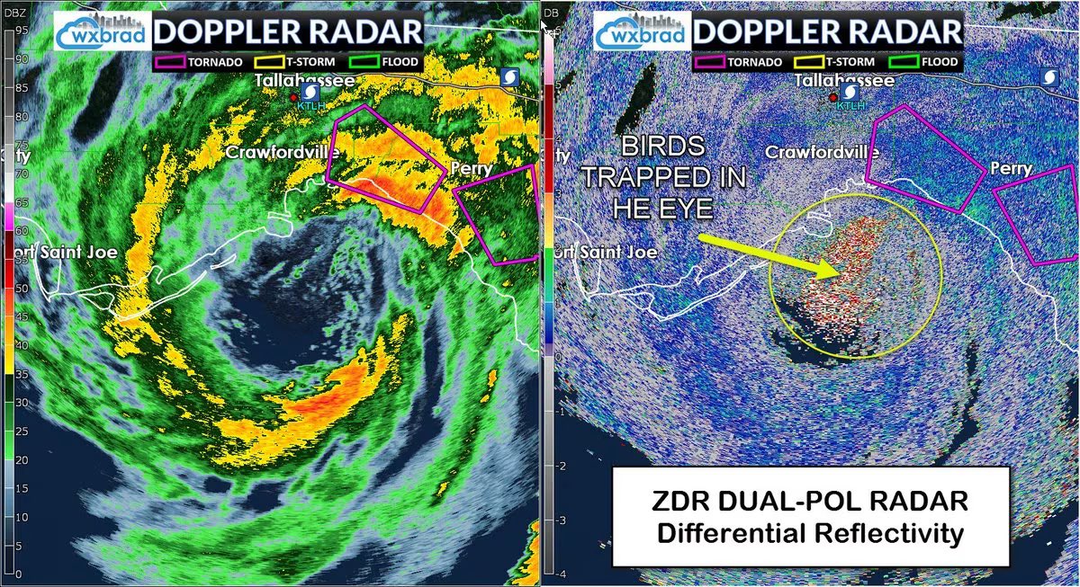
    #WeatherExplained: Birds often get trapped in the eye of formidable hurricanes and get carried long distances until the storm impacts land and weakens. Here is an image from Hurricane Hermine in 2016. Image credit to Brad Panovich and Capital Weather Gang.
    Download
    Tampa Bay Times @TB_Times
    Over the past week, folks around Florida have photographed groups of wild flamingos. They are rare in Tampa Bay, but seeing them is a good thing. The theory is that Hurricane Idalia swept up the pink birds and pushed them farther north than they intended to go. Read more:
    22410532.8K
  3. Tampa Bay Times✓@TB_Times
    Over the past week, folks around Florida have photographed groups of wild flamingos. They are rare in Tampa Bay, but seeing them is a good thing. The theory is that Hurricane Idalia swept up the pink birds and pushed them farther north than they intended to go. Read more:
    Download
    103216857.3K
  4. Sammy Hadi@SammyHadiWx
    #WeatherExplained: A breakdown of the IMME Ensemble 500mb Height Anomaly Forecast that has been trending on #WxTwitter over the last 24 hours.
    Download
    Eric Webb @webberweather
    This month's IMME Ensemble Mean 500mb height anomaly forecast for the peak of this yr's Atlantic Hurricane Season is downright ugly. Blocking highs like this in SE Canada (🔴) are usually associated w/ more frequent hurricane landfalls on the US coastline.
    41161
  5. Eric Webb@webberweather
    This month's IMME Ensemble Mean 500mb height anomaly forecast for the peak of this yr's Atlantic Hurricane Season is downright ugly. Blocking highs like this in SE Canada (🔴) are usually associated w/ more frequent hurricane landfalls on the US coastline.
    Download
    3171329
  6. Sammy Hadi@SammyHadiWx
    #WeatherExplained: #Beryl’s Quadrants Due to Beryl’s angle of approach, the entirety of the island of Jamaica (including the capital, Kingston) will experience the worst quadrant of the storm. Storm surge of 6-9 feet (NHC) & quick moving tropical tornadoes are possible today.
    Download
    KeviShader @KeviShader
    While looking sheared to hell and back on satellite, #Beryl's northern eyewall is packing winds of at least 120-125KT according to a new NOAA recon pass. Unfortunately, this quadrant is forecast to pass close to Jamaica later today, bringing intense impacts to the island nation.
    1125714.6K
  7. KeviShader@KeviShader
    While looking sheared to hell and back on satellite, #Beryl's northern eyewall is packing winds of at least 120-125KT according to a new NOAA recon pass. Unfortunately, this quadrant is forecast to pass close to Jamaica later today, bringing intense impacts to the island nation.
    Download
    196118.8K
  8. Sammy Hadi@SammyHadiWx
    Great example of an Island Sea-Breeze over Grand Bahama. #WeatherExplained #SciFriday
    Download
    James Spann @spann
    Thunderstorm cluster over Grand Bahama on Wednesday… photo from Jonathan Pharr
    6113450
  9. James Spann✓@spann
    Thunderstorm cluster over Grand Bahama on Wednesday… photo from Jonathan Pharr
    Download
    362392
  10. Sammy Hadi@SammyHadiWx
    #WeatherExplained: How the Central American Gyre (C.A.G.) may lead to some tropical development next week. Here is a simple explainer graphic in four steps!
    Download
    12970
  11. Sammy Hadi@SammyHadiWx
    #WeatherExplained: The (Continental) 'Shelf and Surge! Due to a shallow and gently sloping continental shelf, much of the coastline of the Gulf of Mexico is surge-prone. Hence why #Ian and #Idalia both produced significant surge values.
    Download
    027909
  12. Sammy Hadi@SammyHadiWx
    #WeatherExplained: Hurricane Fiona and Puerto Rico's Terrain Explained. 1) Moist tropical airmass 2) Strong southerly winds into the southern side of the mountains 3) Air flowing up the mountains (upslope flow) 4) The moist air rises and creates convection (orographic lift)
    Download
    31960
  13. NWS Miami@NWSMiami
    #WeatherExplained: The Science Behind The Heat Index🥵 Compared to the actual air temperature, the heat index (a.k.a. the feels-like temp.) is a better measure of how the temperature feels to the human body. Today, Miami International Airport recorded a heat index of 114°F.
    Download
    330488.4K
  14. Windy.com✓@Windycom
    You see it every day, but do you know why the sky is blue? 🌍 It’s not just a pretty color, it’s physics at work. We broke it down for you in under 1 minute. Watch to get a new perspective on your daily view of the sky ☀️ #Weatherexplained #Windy
    Download
    12102.1K
  15. Sammy Hadi@SammyHadiWx
    Why do Tropical Cyclones maintain intensity or even strengthen slightly inland over the Everglades? Due to evaporation from "Wet" Soils, a.k.a. the Brown Ocean Effect. #TD19 #WeatherExplained #DYK
    Download
    0932
  16. Sammy Hadi@SammyHadiWx
    #WeatherExplained: Regardless of how the system in the northwestern Caribbean Sea develops as it moves northward, the Florida Peninsula will reside on the eastern side. Deep tropical moisture via southerly winds will stream across the area bringing the potential of heavy rain.
    Download
    125579
  17. Show more posts