Posts with #XArray
#XArray
Public posts on X that use #XArray.
Related hashtags

Benoît Bovy@benbovyBTW, I've used xmovie to create the animation below. It's one of these tools that make life easier! #xarray #matplotlibBenoît Bovy @benbovy@WSchwanghart @PhilippeSteer That's interesting! I've tried reproducing your figure (+ tracking some grid nodes on the S/A plot) using @fastscape with MFD, it looks like a volcano eruption.1839
Benoît Bovy@benbovy@WSchwanghart @PhilippeSteer That's interesting! I've tried reproducing your figure (+ tracking some grid nodes on the S/A plot) using @fastscape with MFD, it looks like a volcano eruption.049
Ujaval Gandhi@spatialthoughtsNew #XArray + #GeoPandas tutorial for fast sampling of geospatial rasters. Learn how XArray can be used efficiently to extract data that is orders of magnitudes faster than other Python packages08785.2K
New #xarray release v0.10.1 is out, with new IO (Iris and Zarr support) and plotting options, among many other option. Thanks to everyone who contributed!02358
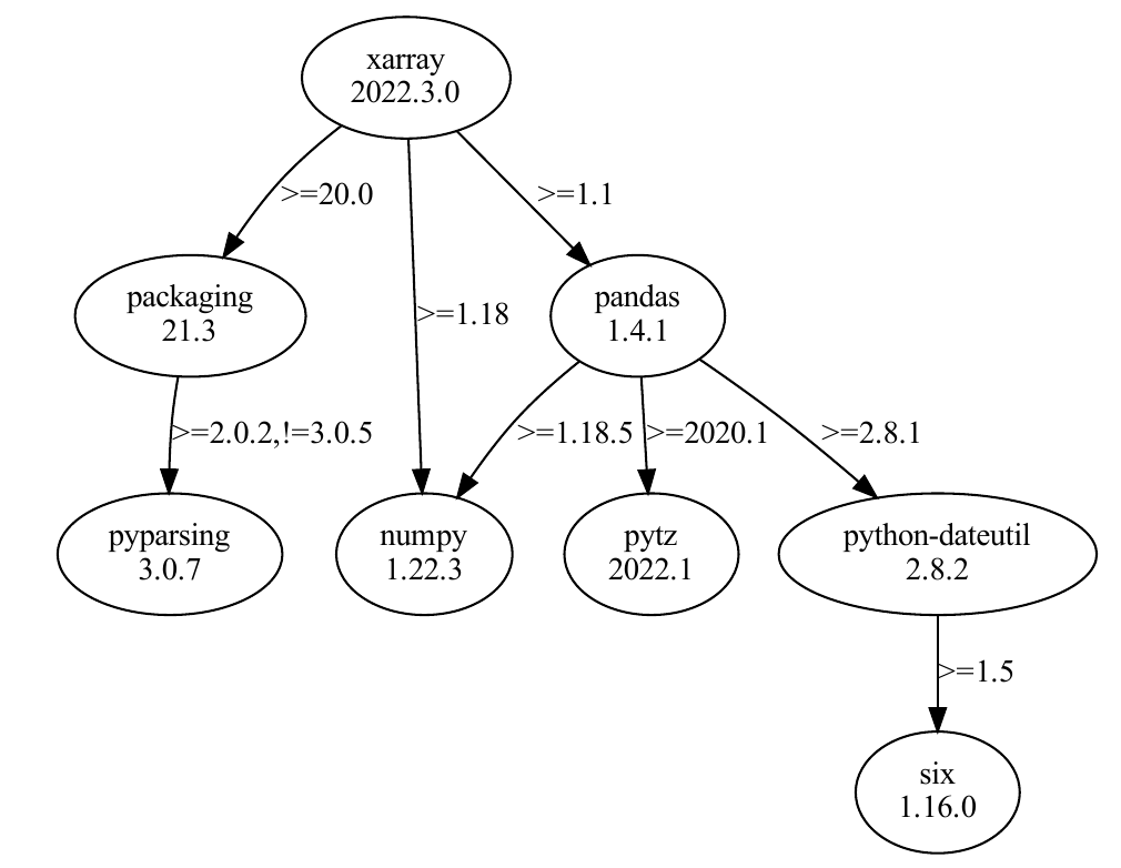
Daily Python Tip 🐍🐧@python_tipPipdeptree is a command-line tool that displays installed Python packages in a dependency tree. #pipdeptree + #xarray + #graphwiz = nice DAG visualization of your dependencies 👇👇Qiusheng Wu @giswqsJust found a nice #Python package for visualizing package dependency tree with only one line of code pip install pipdeptree graphviz pipdeptree -p xarray --graph-output pdf > dependencies.pdf #xarray #geospatial05387.2K
Just found a nice #Python package for visualizing package dependency tree with only one line of code pip install pipdeptree graphviz pipdeptree -p xarray --graph-output pdf > dependencies.pdf #xarray #geospatial115119
Ujaval Gandhi@spatialthoughtsWant to level up your #Python Dataviz skills? I am launching our Mapping and Data Visualization with Python course on YouTube and designed a free #PythonDatavizChallenge where you spend 30 mins a day for the next 30 days to learn a new skill. Start at413663131.6K
Ujaval Gandhi@spatialthoughts@spatialthoughtsWe learn how to visualize satellite imagery by querying a STAC Catalog of Sentinel-2 imagery and learning how to work with time-series data with #XArray. We create a median RGB composite and visualize it using #MatPlotlib101432
Ujaval Gandhi@spatialthoughts@spatialthoughtsWe end the day by learning how #XArray makes temporal aggregation a breeze and create monthly median composites with just 1 line of code and visualize all 12 images using #Matplotlib132544
Ujaval Gandhi@spatialthoughts@spatialthoughtsWorking with large files like these can be tricky with traditional Python libraries like rasterio. You can easily run out of RAM and processing is slow. The #XArray ecosystem makes it a pleasure to work with the data. We read the bands using #rioxarray. (3/n)10101.2K
Exciting news for the geospatial community! A new dedicated platform is now available for open-source geospatial Python tutorials, featuring #GeoPandas, #XArray, #Dask, and more. A great resource for anyone working with geospatial data. Thank you, @spatialthoughts, for making these valuable tutorials accessible! #Geospatial #Python #DataScience #OpenSourceUjaval Gandhi @spatialthoughtsLaunching a new home for all our open-source geospatial python tutorials - covering #GeoPandas, #XArray, #Dask, #XEE, #SamGeo and more. Check them out at0171.4K
Ujaval Gandhi@spatialthoughtsLaunching a new home for all our open-source geospatial python tutorials - covering #GeoPandas, #XArray, #Dask, #XEE, #SamGeo and more. Check them out at816965127.1K
Irene@igarciamarti@igarciamartiI quickly jumped to #QGIS to find out why my 3GB tile at 1m resolution could not be resampled at 100m. Luckily, the #grassgis resample module managed this task with no problem and a reduced memory usage. So it was not my computer, but something unknown within #xarray library.112274
Fabian Hofmann@fabianmarik🚀 You like optimization? And you love Python? Then, check out Linopy, a new, open-source Python package 🐍 that makes linear and MILP optimization fast and memory-efficient. The best thing: You can use array-like operations & indexing like you're used to from #pandas & #xarray2196212.5K
Digital Earth Africa@DEarthAfricaWant to access EO data in the cloud using Xarray? This beginner-friendly talk by Marco Wolsza (NITheCS Micro School) features DEarthAfrica tools & datasets. Great intro to working with open geospatial data! Watch here: #EO #Xarray #OpenData0115356
Yohei Takano@YoheiTakano3When I am working on laptop or desktop, I use xarray+NetCDF but should I know consider using zarr? I see nice things working on cloud storages from brief reading but would like to know more about the advantage (#python, #xarray)102
Lorena Abad@loreabad6@Zjbb@Zjbb @Lidefi87 @AcademicChatter @r0mymendez @rladiesgps Not a lot of experience with Python, could be xarray and rioxarray for raster. Maybe @giswqs or @csaybar could give some more hints? 😊102
@loreabad6@loreabad6 @Zjbb @Lidefi87 @AcademicChatter @r0mymendez @rladiesgps @csaybar Try out the xarray-spatial #Python package by @makepathGIS #gis #xarray #gischat #eochat126
Looking for an easy way to search, download, or stream @NASAEarth science data in a few lines of code? earthaccess is the library for you! #xarray #Python #OpenScience #NSIDCDAAC #LPDAAC #CloudComputing #openscapes05516614.6K- Show more posts